
Khumbu (also known as the Everest Region)is a region of
northeastern Nepal on the Nepalese side of Mount Everest. It is part of the
Solukhumbu District, which in turn is part of the Sagarmatha Zone. Khumbu is
one of three subregions of the main Khambu (specially Thulung) and Sherpa
settlement of the Himalaya, the other two being Solu and Pharak. It includes
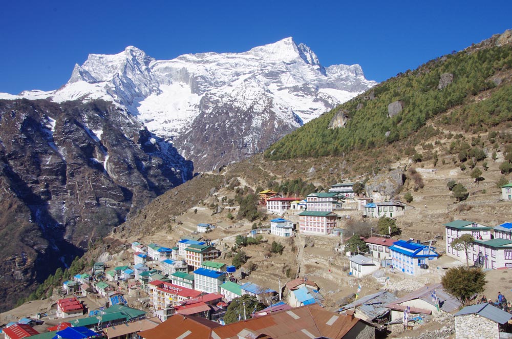
the town of Namche Bazaar as well as the villages of Thame, Khumjung,
Pangboche,Pheriche and Kunde. The famous Buddhist monastery at Tengbocheis also
located in the Khumbu.
The Khumbila mountain rising aboveKhumjung and Kunde, two of
the larger villages in the area, with Mount Everest,Lhotse and Ama Dablam in
the background.
The Khumbu's elevation ranges from 3,300 metres (11,000 feet)
to the 8,848 m (29,029 ft) summit of Mount Everest, the highest place on
Earth.[4]Sagarmatha National Park (above Monju) and the Sagarmatha National
Park Buffer Zone (between Lukla and Monju) are enclosed within the Khumbu
region.
The Khumbu is a glacier believed to be the result of the last
great Ice Age, ~500,000 years
Chukhung is a lodge village serving trekkers and climbers in
the Khumbu Region of Nepal in the Himalayas south of Mount Everest.
The Chukhung Valley lies on the southern slopes of Lhotse and
Nuptse by the Lho Glacier and the Nup Glacier, the western slopes ofCho Polu
and Baruntse by the Imja Glaciers, and the northern slopes of Mount Ama Dablam
by the Ama Dablam Glacier and Chukhung Glacier. It extends westward past the
village of Dingboche where it joins the Pheriche Valley. The Imja Khola flows
through the Chukhung Valley.
Chukhung village, 4,730 metres (15,518 ft), is on a left fork
of the Imja Khola at . Administratively it is in the Rasuwa District of the
Bagmati Zone. This area was traditionally used as a yak pasture with no
permanent habitation. As Imja Tse has gained popularity as a trekking peak and
the Chukhung Valley is a good acclimatization side trip for Everest Base Camp
trekkers, several lodges have been built there.
Chukhung Ri is a rocky peak, similar to Kala Pattar, above
the village of Chukhung. It takes three hours or less to reach the summit from
Chukhung and it requires no technical climbing. The summit has astounding views
of Imja Tse (Island Peak), Ama Dablam, Makalu, and the Lhotse face, and it is a
worthwhile addition to any climbing or trekking itinerary in the Khumbu region.
Everest base camp Trekking tour hiking Travel
The Everest Base Camp is two base camps, each on opposite sides of Mount Everest. South Base Camp is in Nepal at an altitude of 5,364 meters (17,598 ft) (28°0′26″N 86°51′34″E), and North Base Camp is in Tibet at 5,150 meters (16,900 ft) (28°8′29″N 86°51′5″E). These camps are rudimentary campsites on Mount Everest that are used by mountain climbers during their ascent and descent. South Base Camp is used when climbing via the southeast ridge, while North Base Camp is used when climbing via the northeast ridge.
Supplies are carried to the South Base Camp by sherpas or porters, and with help of animals, usually yaks. The North Base Camp has vehicle access (at least in the summer months). Climbers typically rest at base camp for several days for acclimatization; to reduce the risks and severity of altitude sickness.
The Everest Base Camp trek on the south side is one of the most popular trekking routes in the Himalayas and is visited by thousands of trekkers each year. Trekkers usually fly from Kathmandu to Lukla to save time and energy before beginning the morning trek to this base camp. From Lukla, climbers trek upward to the Sherpa capital of Namche Bazaar, 3,440 meters (11,290 ft), following the valley of the Dudh Kosi river. The village is a central hub of the area, and food, sundries and even mountain climbing equipment may be purchased here.
This takes about two days. Typically at this point, climbers allow a day of rest for acclimatization. They then trek another two days to Dingboche, 4,260 meters (13,980 ft) before resting for another day for further acclimatization. Another two days takes them to Everest Base Camp via Gorakshep, the flat field below Kala Patthar, 5,545 meters (18,192 ft) and Mt. Pumori.
http://www.nepalguideinfo.com/
http://www.nepalguideinfo.com/
http://www.hikehimalayas.com/
Email-:sanjib-adhikari@hotmail.com
P.O. BOX=4453 Kathmandu Nepal